What if you could stand outside a building and instantly know its emissions profile? What if your smart assistant not only told you what you’re looking at, but also knew where you were standing – and why it mattered? What if old geological records, long buried in PDF archives, could be transformed into dynamic maps that help homeowners tap into clean energy? And what if we could train AI models to anticipate how our landscapes will change – not in theory, but block by block, year by year?
At the April meeting of the TGI GeoAI Working Group, we saw all of that — not as distant possibilities, but as real projects underway. This was the third installment in a special presentation series featuring awardees of the TGI-AWS Generative AI Challenge, a program launched last year to accelerate innovation at the intersection of AI and geospatial science. From over 100 applications, ten winning teams were selected to receive funding and AWS cloud credits to bring their bold ideas to life.
“These presentations really show the breadth of innovation taking place in the GeoAI space — from tools that help individual users to systems designed for large-scale community impact,” said Marge Cole, Strategic Initiatives Director, TGI, and who moderated the session. “It’s exciting to see how far we have come in just a few months since the Challenge kicked off.”
Those insights set the tone for the presentations that followed from the next cohort of winners – Deep Earth, Zephr.xyz, Clark University, and Crosswalk Labs. And each presentation made one thing clear: GeoAI is no longer an emerging concept – it’s already showing up in practical, scalable ways.
Reports from our previous Geo AI Working Group Meetings:
Deep Earth: Bringing Subsurface Intelligence to the Surface

Can I Install a Geothermal System at Home? That’s the deceptively simple question the team from Deep Earth set out to answer. Represented by co-founder Christie Capper and her colleague Johannes Hansen, the duo shared how they’re using generative AI to make old geological data useful again. They walked the participants through their AI-powered prototype that analyzes subsurface geology and energy use data to determine whether geothermal systems are viable for a given property.
While their current focus is on Illinois, the long-term goal is a nationwide platform that could help building owners transition to cleaner heating and cooling systems. What sets their approach apart is the use of generative AI to extract information from thousands of historical geological reports – many of them scanned documents or PDFs – and turn that into spatially relevant layers such as depth to bedrock and water table location.
The result? A sleek, user-friendly app that lets someone enter a ZIP code or address and see a financial and technical viability analysis for installing a geothermal system, along with maps showing existing systems, subsurface conditions, and potential conflicts. And it’s all built with real geospatial intelligence stitched together from fragmented data sources.
“Our prototype helps people understand their geothermal potential in plain language, even if they know nothing about geology,” Capper explained. “It’s about making clean energy more approachable and actionable.”
Zephr.xyz: Teaching AI to See the World Spatially

Next, Sean Gorman, Co-Founder and CEO, Zephr.xyz, demonstrated how his team is working on making large language models (LLMs) aware of the physical world. The idea? When you’re walking down the street, your AI assistant should know not just what you’re saying, but what you’re looking at.
Gorman shared how they are using precise GNSS data, sensor inputs from devices like phones and wearables, and the open-source Overture Maps database to give AI that kind of spatial awareness. In a demo, a headset-wearer looked at a bakery and asked what it was. The assistant replied with its name, customer rating, and even a popular menu item — all inferred from position, orientation, and AI-generated context.
“We are not using cameras or visual recognition here,” he emphasized. “We are relying on geospatial knowledge and real-time positioning to let the AI reason about the world – just like a human would.”
It’s futuristic, but grounded in real tech – and it opens up a whole new category of location-based assistants, especially in AR and hands-free navigation scenarios.
Clark University: Predicting Tomorrow’s Landscapes

Next up was Dr. Hamed Alemohammad, Director, Clark Center for Geospatial Analytics, and Associate Professor, Clark University, who is working on building a generative model to forecast how land use and land cover might change over time in the U.S., starting with data from the National Land Cover Database and expanding to incorporate satellite imagery, elevation, temperature, and population growth.
The model uses diffusion-based AI – similar to what powers AI image generators, but instead of turning prompts into artwork, it creates future maps of land cover based on real-world environmental trends. Alemohammad explained how the system is being trained to detect patterns like urban expansion or deforestation and then project them forward.
“Most land use models are pixel-based and static,” he said. “We are trying to give the AI context — a sense of landscape and trend, so that it can not only spot change but anticipate it.”
The applications are big: from planning infrastructure to biodiversity conservation, these maps could offer a valuable window into the future of our environment.
Crosswalk Labs: Solving ‘Missing Data’ Problem in Emissions Modeling

Daniel Sheehan, Director of Solutions Architecture at Crosswalk Labs, closed the session with a practical GenAI application: verifying building-level data to improve emissions and energy modeling accuracy.
“At Crosswalk Labs, we ingest open and commercial activity data, apply bottom-up greenhouse gas emissions modeling, and publish standardized emissions data to open.crosswalk.io and arc.crosswalk.io. Like many organizations, we face challenges related to missing, inaccurate, incomplete, and duplicative data,” he said.
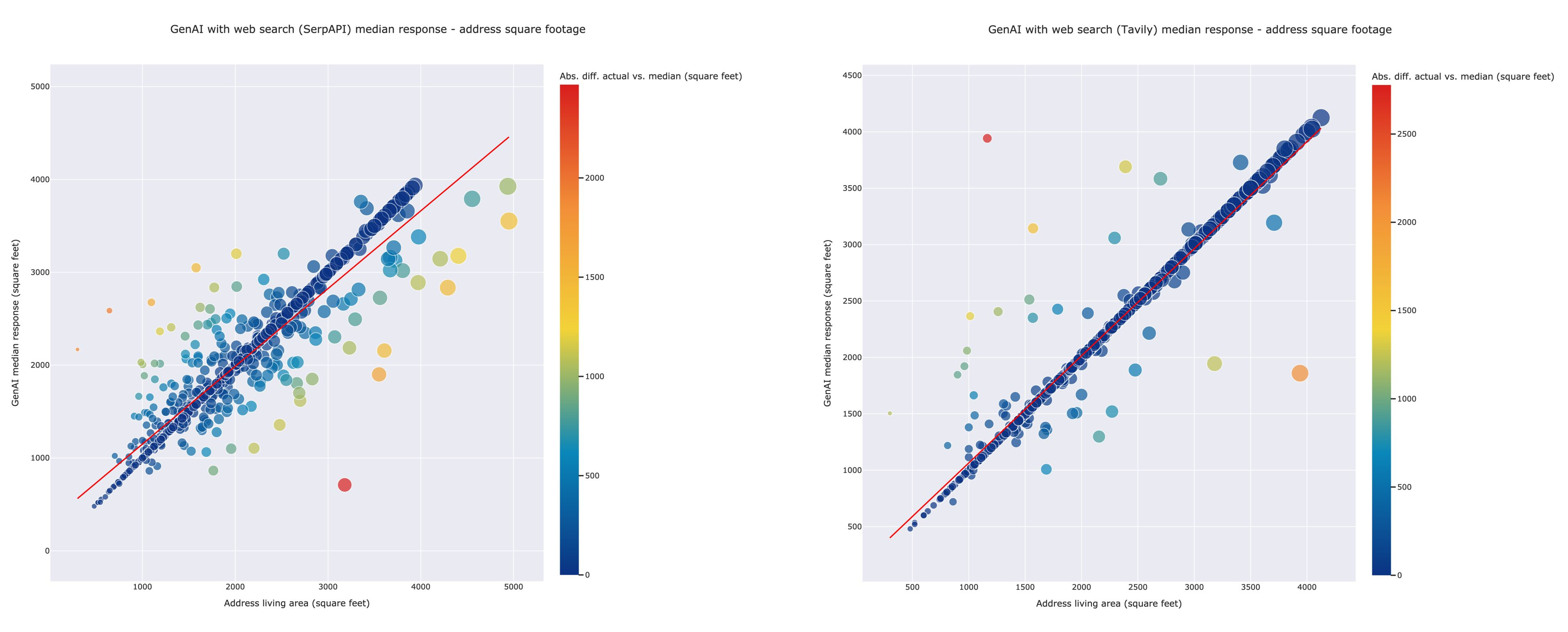
To address these issues, the team explored using Generative AI and dynamic web search APIs for data gap-filling, specifically for the building area (square footage) attribute in U.S. building stock. By combining dynamic web search-based enrichment from APIs like Tavily and SerpAPI with Amazon Web Services’ fully managed GenAI service, Amazon Bedrock, the team achieved promising results with high accuracy for our data gap-filling use case.
Early results show strong performance, and the team sees potential for this kind of pipeline in everything from ESG compliance to real estate analytics.
Shaping What’s Next, Together
What tied all four presentations together wasn’t just the technology – it was the real-world relevance. Each team is applying AI to a tangible challenge, whether it’s improving energy efficiency, transforming urban mobility, forecasting environmental change, or addressing data gaps at scale. And they’re doing it by combining deep domain knowledge with technical ingenuity.
These projects embody the collaborative ethos of the TGI GeoAI Working Group – a space where startups, researchers, and institutions come together to co-create bold, data-driven solutions at the intersection of geospatial science and AI. As the Challenge enters its final stretch, the momentum is only growing.
Don’t miss the final part of this GeoAI Working Group series scheduled for May 1, 2:00 pm CDT — 4:00 pm CDT, where the remaining awardees will present their groundbreaking work.
We will hear from:
- Darryl Murdock, Vice President, Federal Geospatial Services, Avineon on fire model prediction
- Dong Xu, Curators’ Distinguished Professor at University of Missouri-Columbia on deforestation and biodiversity changes
- Mikel Maron, Product Lead at Earth Genome on rapid environmental monitoring and agriculture
The future of GeoAI is still unfolding – and you are invited to be part of it. Register here
About Taylor Geospatial Institute
TGI is passionate about fueling geospatial science and technology to create the next generation of solutions and policies that the whole world will depend on for sustainability and growth.
The TGI consortium includes Saint Louis University, the Donald Danforth Plant Science Center, Harris-Stowe State University, University of Illinois Urbana-Champaign, Missouri University of Science & Technology, University of Missouri-Columbia, University of Missouri-St. Louis, and Washington University in St. Louis. Collectively, these institutions cover geospatial research from ocean depths to outer space.
For more information, visit taylorgeospatial.org.
