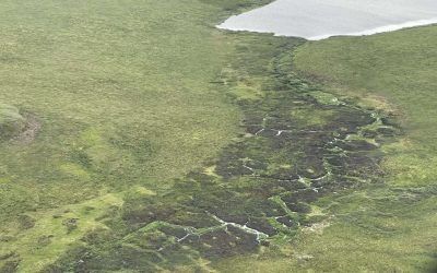
By Bob Grant In 2023, Shaowen Wang, Ph.D., was awarded a block grant from the Taylor Geospatial Institute to use geospatial technologies and artificial intelligence to reimagine the ways that water features, such as rivers and streams, are mapped as they wind across...
University of Illinois
TGI-funded Project Uses Geospatial Tech to Study Permafrost, Plants, and Wildfire
By Bob Grant The arctic tundra is a surprisingly dynamic ecosystem that at first glance appears to be a windswept, frigid wasteland. But further investigation reveals that it hosts hundreds of plant species—mostly shrubs, mosses, and grasses— that jockey for space...
TGI Announces New LinkedIn Group: The TGI Research and Technology Hub
by Bob Grant During the week of February 26th, TGI announced a new LinkedIn Group to help researchers, administrators, and others share award opportunities, requests for proposals, emerging geospatial technologies, interesting new publications, and more using the...
A Geospatial Welcome
By Nadine Alameh I’ll start this message the same way I would likely start and end all my communications with the amazing consortium that is the Taylor Geospatial Institute—with a thank you! Thank you for your warm welcome, thank you for your commitment to TGI’s...
Taylor Geospatial Career Guide Series Kicks Off with an Impassioned Presentation of the Potential of Geospatial Science from TGI Executive Director Nadine Alameh
by Bob Grant ST. LOUIS — The Taylor Geospatial Institute launched its Geospatial Career Guide Series by welcoming students, professionals, and anyone else interested in exploring geospatial careers to listen and engage in the first installment on September 14, 2023....
Taylor Geospatial Institute Receives $1 Million NSF Grant to Create Regional AI Learning System
ST. LOUIS – A $1 million grant from the National Science Foundation will create the Taylor Geospatial Institute Regional AI Learning System. Launched in April 2022 and led by Saint Louis University, the Taylor Geospatial Institute brings together eight Midwestern...
NCSA’s Blue Waters Supercomputer Helps Map the Earth
One of the earliest projects to ramp up after NCSA launched the Blue Waters supercomputer in 2013 was a project from the University of Minnesota’s Polar Geospatial Center. They wanted to make high-quality digital elevation models, or DEMs, for the polar ice. Their...
U of I Leads New $15 Million Institute to Understand Climate Change and Disasters
Institute will focus on innovative cyberGIS and cyberinfrastructure A new national initiative to enable geospatial data-driven scientific discovery will create a $15-million institute at the University of Illinois Urbana-Champaign to better understand the risks and...