
By Bob Grant
In 2023, Rekha Meyer, Ph.D., was awarded a seed grant from the Taylor Geospatial Institute to address a geospatial challenge: reducing the use of water in urban gardens. Her TGI-funded project is titled, “Waste not, Want not. A ‘Smart Garden’ approach to water conservation using remote sensing and geospatial technologies for urban agriculture.”
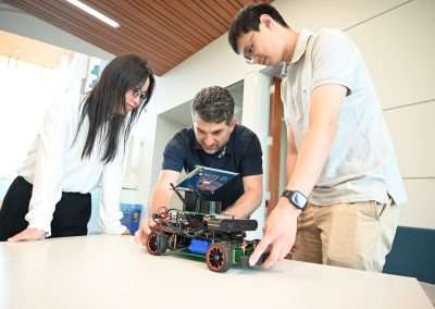
“We had to build a sensing system from scratch that would only water when needed,” said Dr. Meyer, an assistant professor of biological sciences at Harris-Stowe State University. “We used the sunflower as a biomarker for when the watering is necessary. Most of the experiments were done in the greenhouse, but we’re getting ready to go into the garden itself and use what we learn in the greenhouse and apply it there; We’ve made good progress.”
Dr. Meyer and her colleagues developed a system of sensors that can monitor soil moisture in greenhouse conditions and an automated watering component. In addition, the team plans to integrate AI that identifies wilting stages in plants through machine learning, and additional sensors to gather more environmental information, such as humidity, temperature, wind speed, and weather conditions, to further improve water conservation by assuring that water is applied to plants only when necessary.
Plant phenotyping research is often practiced in controlled environments resulting in high quality images. Dr. Meyer and her team were able to resolve quality issues linked to imaging in a greenhouse setting by using custom Python programming in PlantCV. By combining AgriTech and Geographic Information Systems (GIS), Dr. Meyer and her team hope to build a dashboard which will utilize local information on soil type, soil moisture holding capacity and weather forecast to predict irrigation needs in any location and in any environment.
“The surprise was how difficult it was to image the sunflowers in what I would call a real-life setting,” said Dr. Meyer. Because a lot of times when people use plant phenotyping, it’s done in a closed environment. You’ve got these conveyor belts, there’s no changes, there’s nothing going on. The picture is perfect every single time. You can detect disease, you can detect wilting, you can detect a lot of things that way, but in the greenhouse, you’re going to be subjected to what’s happening outside. We’re trying to get around it by maybe imaging the plants only at certain times of the day.”
To help achieve this goal and attempt to provide scale, the team used an array of cost-effective sensors and other tools, such as Raspberry Pi, moisture sensors, and more. After troubleshooting they were able to find an effective solution. With this strategy they were able to track multiple sunflowers in real-time in the garden. By doing so they have moved one step closer to their next goal: to create a geospatial model that allows users to view an area, moisture, etc. to better grow plants.
We’re working on a paper right now,” said Dr. Meyer. “I want to showcase what an HBCU can do in this kind of a setting with support from an organization like TGI. I simply can’t find enough words to say how good it’s been.”
Information about Dr. Meyer’s research can be found at taylorgeospatial.org/associates, a database of all of TGI’s associates showing the unique work they are doing in geospatial.
To stay up to date with TGI activities, subscribe to our newsletter.